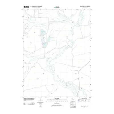
2010 Map of Delaney Butte
USGS Topo · Published 2010About this map
North Delaney Lake, East Delaney Lake, and South Delaney Lake form a central hydrological cluster in this high-country landscape, managed through engineered structures like Laune Dam and Butte Dam. The terrain is defined by the winding course of the North Fork North Platte River and the North Platte River, which are flanked by an extensive network of irrigation ditches. These waterways, including the Legal Tender Ditch and Hell Creek Ditch, underscore the area's historical reliance on water rights for ranching operations. Numerous family-named homesteads such as Briggs Ranch, Sorenson Ranch, and Norrell Ranch are scattered across the quadrangle. Geographic landmarks like Delaney Butte and Peterson Ridge rise above the drainage basins of Spring Gulch and Manville Draw, illustrating the complex topography of this Colorado ranching district.
Find a feature on this map
70 named features on this map. Tap any name to fly to it.
Don’t see what you’re looking for? This feature index may not catch every label — zoom into the map to look around manually.
Map Details
Editions of this 2010 Delaney Butte Map
This is the sole edition of this map. No revisions or reprints were ever made.
Other maps of this area

1911 · Hahns Peak
USGS Topo · 1:125,000

1913 · Hahns Peak
USGS Topo · 1:125,000

1954 · Craig
USGS Topo · 1:250,000

1955 · Lake John
USGS Topo · 1:24,000

1955 · Pitchpine Mountain
USGS Topo · 1:24,000

1955 · Teal Lake
USGS Topo · 1:24,000

1955 · Delaney Butte
USGS Topo · 1:24,000

1955 · Coalmont
USGS Topo · 1:24,000

1955 · Walden
USGS Topo · 1:24,000

1955 · Mac Farlane Reservoir
USGS Topo · 1:24,000