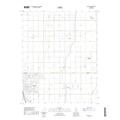
2018 Map of Delano East
USGS Topo · Published 2018About this map
Agricultural development and water management define this portion of the San Joaquin Valley along the border of Tulare and Kern Counties. The city of Delano anchors the southwestern corner, showing a detailed street grid and the Delano Municipal Airport nearby. North of the city, the landscape is dominated by a systematic network of section roads like Ave 32 and Rd 160, supporting the region's intensive farming. The Friant-Kern Canal cuts a distinctive path through the eastern half of the map, a vital artery for irrigation that crosses the seasonal White River. Several smaller settlements and labor centers, including Jovista, Trocha, and Rodriguez Camp, are situated along these transit and water corridors, reflecting the area's history as a hub for industrial-scale agriculture and transport logistics.
Find a feature on this map
110 named features on this map. Tap any name to fly to it.
Don’t see what you’re looking for? This feature index may not catch every label — zoom into the map to look around manually.
Map Details
Editions of this 2018 Delano East Map
This is the sole edition of this map. No revisions or reprints were ever made.
Other maps of this area

1927 · McFarland
USGS Topo · 1:31,680

1929 · Delano
USGS Topo · 1:31,680

1929 · Sausalito School
USGS Topo · 1:31,680

1929 · Richgrove
USGS Topo · 1:31,680

1929 · Pixley
USGS Topo · 1:31,680

1929 · Stone
USGS Topo · 1:31,680

1929 · Ducor
USGS Topo · 1:31,680

1930 · McFarland
USGS Topo · 1:31,680

1930 · Pond
USGS Topo · 1:31,680

1931 · Deepwell Ranch
USGS Topo · 1:31,680
Featured Places
- Delano, CA
- Cypress Gardens Mobile Home Community, Delano
- Delano Mobile Home Park, Delano
- Kern County, CA
- Tulare County, CA