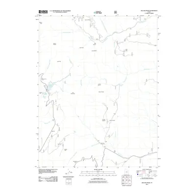
2011 Map of Delano Peak
USGS Topo · Published 2011About this map
Delano Peak towers over this section of the Tushar Mountains in south-central Utah, anchoring a landscape defined by high-elevation ridges and alpine water systems. The map illustrates a network of lakes and reservoirs near the western boundary, including Puffer Lake, Mirror Lake, and Otter Lake, supported by engineering works like Puffer Lake Dam and Blainies Dam. These water sources feed complex drainages such as Lake Stream and North Fork Three Creeks.
Find a feature on this map
41 named features on this map. Tap any name to fly to it.
Don’t see what you’re looking for? This feature index may not catch every label — zoom into the map to look around manually.
Map Details
Editions of this 2011 Delano Peak Map
This is the sole edition of this map. No revisions or reprints were ever made.
Other maps of this area

1885 · Beaver
USGS Topo · 1:250,000

1937 · Delano Peak
USGS Topo · 1:48,000

1943 · Delano Peak
USGS Topo · 1:62,500

1945 · Marysvale
USGS Topo · 1:62,500

1947 · Marysvale
USGS Topo · 1:62,500

1953 · Richfield
USGS Topo · 1:250,000

1958 · Richfield
USGS Topo · 1:250,000

1966 · Circleville
USGS Topo · 1:24,000
1966 · Junction
USGS Topo · 1:24,000
1971 · Circleville Mtn
USGS Topo · 1:24,000