
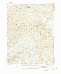
1937 Map of Delano Peak
USGS Topo · Published 1937About this map
Fishlake National Forest dominates this high-altitude 1937 survey, where the mining industry has left a heavy footprint across the Tushar Mountains. The map documents a cluster of significant silver and gold operations, including the Sevier Mine and Annie Laurie Mine near the settlements of Upper Kimberly and Lower Kimberly. These mountain camps were built around the rich veins of the Gold Mountain district, which transitioned into the more industrially focused aluminum mining seen at Alunite along Highway No 89. The landscape is a complex network of high peaks like Delano Peak and Mt Belknap, interspersed with alpine landmarks such as Puffer Lake and the dramatic Bullion Falls. From the Deer Creek Guard Sta to the scattered mining claims like the Bully Boy Mine, the map captures the late-stage development of a storied Utah mineral belt before many of these camps faded.
Find a feature on this map
101 named features on this map. Tap any name to fly to it.
Don’t see what you’re looking for? This feature index may not catch every label — zoom into the map to look around manually.
Map Details
Editions of this 1937 Delano Peak Map
2 editions found
Other maps of this area

1885 · Beaver
USGS Topo · 1:250,000

1932 · Sevier
USGS Topo · 1:62,500

1935 · Sevier
USGS Topo · 1:62,500

1940 · Monroe
USGS Topo · 1:62,500

1943 · Delano Peak
USGS Topo · 1:62,500

1944 · Monroe
USGS Topo · 1:62,500

1945 · Marysvale
USGS Topo · 1:62,500

1947 · Marysvale
USGS Topo · 1:62,500

1953 · Richfield
USGS Topo · 1:250,000

1954 · Beaver SE
USGS Topo · 1:24,000