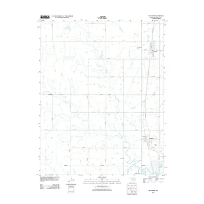
2013 Map of Delaware
USGS Topo · Published 2013About this map
The town of Delaware and the community of Lenapah anchor this eastern Oklahoma landscape in the early 21st century. Situated in Nowata County, the area is defined by the winding course of California Cr and Wolf Cr, which drain the surrounding plains. The local infrastructure follows a rigid section-line grid, exemplified by routes like e0150 RD and N 4110 RD, though the natural hydrology of Mormon Cr and the Glenn-Webster Reservoir creates breaks in this geometric pattern. Genealogists and local historians can pinpoint significant community landmarks such as Mt Washington Cem north of Lenapah and Bezoin Cem further south. Smaller settlements like Ruthdale and Cedar Bluff provide context for the rural distribution of homes and farms, while the detailed street plans for the primary towns include locally significant thoroughfares such as Shawnee Ave, Cherokee ST, and Elevator ST.
Find a feature on this map
45 named features on this map. Tap any name to fly to it.
Don’t see what you’re looking for? This feature index may not catch every label — zoom into the map to look around manually.
Map Details
Editions of this 2013 Delaware Map
This is the sole edition of this map. No revisions or reprints were ever made.
Other maps of this area

1901 · Nowata
USGS Topo · 1:125,000

1914 · Nowata
USGS Topo · 1:125,000

1954 · Tulsa
USGS Topo · 1:250,000

1958 · Tulsa
USGS Topo · 1:250,000

1963 · Tulsa
USGS Topo · 1:250,000

1972 · Blue Mound
USGS Topo · 1:24,000
1972 · Elliott
USGS Topo · 1:24,000

1972 · Nowata West
USGS Topo · 1:24,000
1972 · Delaware
USGS Topo · 1:24,000
1972 · Oglesby
USGS Topo · 1:24,000