
1901 Map of Nowata
USGS Topo · Published 1901About this map
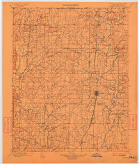
The Verdigris River snakes through the heart of the Cherokee Nation in this detailed survey of the Indian Territory. The settlement of Nowata serves as a central hub, appearing at the intersection of the St. Louis and Southern R. R. and the developing town grids. The map reveals a landscape defined by an extensive network of creeks and prairie drainages, such as Cotton Creek and Lightning Creek, which dictated the early settlement patterns of Cherokee families and incoming settlers.
Find a feature on this map
63 named features on this map. Tap any name to fly to it.
Don’t see what you’re looking for? This feature index may not catch every label — zoom into the map to look around manually.
Map Details
Editions of this 1901 Nowata Map
2 editions found
Other maps of this area

1885 · Sedan
USGS Topo · 1:125,000

1886 · Independence
USGS Topo · 1:125,000

1886 · Parsons
USGS Topo · 1:125,000

1889 · Sedan
USGS Topo · 1:125,000

1893 · Parsons
USGS Topo · 1:125,000

1894 · Independence
USGS Topo · 1:125,000

1896 · Pryor
USGS Topo · 1:125,000

1901 · Claremore
USGS Topo · 1:125,000

1901 · Vinita
USGS Topo · 1:125,000

1901 · Pryor
USGS Topo · 1:125,000