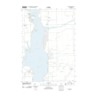
2010 Map of Dellwood
USGS Topo · Published 2010About this map
Castle Rock Lake and the Wisconsin River dominate the western portion of this Adams County landscape, illustrating a complex hydraulic environment defined by broad water bodies and intricate drainage systems. The small community of Dellwood sits along the eastern shore, served by a network of local roads such as County Hwy-Z and Czech Ave. The local topography is varied, featuring the prominent Quincy Bluff in the southeast and the artificial Schwahn 3NC78806 Dam near 17 Reservoir. Genealogy and local history are anchored by the Dellwood Cemetery and Quincy Cemetery, while the presence of the Dellaire Landing Strip and Whistling Wings Landing Strip highlights the area's recreational or private aviation activity. Numerous watercourses, including Little Roche a Cri Creek, Klein Creek, and the Castle Rock Ditch, feed into the central reservoir, shaping the low-lying terrain north of Edgewood Ave.
Find a feature on this map
47 named features on this map. Tap any name to fly to it.
Don’t see what you’re looking for? This feature index may not catch every label — zoom into the map to look around manually.
Map Details
Editions of this 2010 Dellwood Map
This is the sole edition of this map. No revisions or reprints were ever made.
Other maps of this area

1921 · Mauston
USGS Topo · 1:62,500

1953 · Eau Claire
USGS Topo · 1:250,000

1955 · Green Bay
USGS Topo · 1:250,000

1957 · Madison
USGS Topo · 1:250,000

1958 · Eau Claire
USGS Topo · 1:250,000

1958 · Arkdale
USGS Topo · 1:48,000

1958 · Necedah
USGS Topo · 1:48,000

1958 · La Crosse
USGS Topo · 1:250,000

1960 · Madison
USGS Topo · 1:250,000

1961 · La Crosse
USGS Topo · 1:250,000