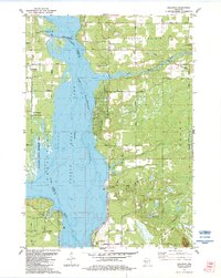
1983 Map of Dellwood
USGS Topo · Published 1984About this map
Castle Rock Lake and the Wisconsin River dominate this Central Wisconsin landscape, serving as the central dividing line between Adams and Juneau counties. The settlement of Dellwood sits on the eastern shore, characterized by a dense grid of residential streets like Dakota Ave and Deerborn Drive. The surrounding landscape is a mix of conservation and recreation, with Buckhorn State Park and the Buckhorn State Wildlife Area occupying the peninsula to the west. Evidence of local aviation is seen at the Dellaire Landing Strip and Whistling Wings Landing Strip. To the southeast, the terrain rises toward Quincy Bluff, overlooking Duck Creek and Silver Lake. The Chicago and North Western railroad cuts across the northern landscape, while local history is preserved at the Quincy Cem and the Our Lady of the Lake church.
Find a feature on this map
45 named features on this map. Tap any name to fly to it.
Don’t see what you’re looking for? This feature index may not catch every label — zoom into the map to look around manually.
Map Details
Editions of this 1983 Dellwood Map
This is the sole edition of this map. No revisions or reprints were ever made.
Other maps of this area

1921 · Mauston
USGS Topo · 1:62,500

1953 · Eau Claire
USGS Topo · 1:250,000

1955 · Green Bay
USGS Topo · 1:250,000

1957 · Madison
USGS Topo · 1:250,000

1958 · Eau Claire
USGS Topo · 1:250,000

1958 · Arkdale
USGS Topo · 1:48,000

1958 · Necedah
USGS Topo · 1:48,000

1958 · La Crosse
USGS Topo · 1:250,000

1960 · Madison
USGS Topo · 1:250,000

1961 · La Crosse
USGS Topo · 1:250,000