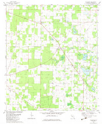
1982 Map of Dellwood
USGS Topo · Published 1983About this map
Two Egg and Dellwood anchor this Jackson County landscape in the early 1980s, revealing a rural community defined by its water-pocked terrain and agricultural roots. The map is notably dense with localized ponds and small basins, from the central Fivemile Pond to the clustered Cow Pen Pond and Wolf Head Pond in the east. These water bodies, often bearing specific family or descriptive names like Rat Pond and Brandy Beach Pond, suggest a landscape where water management and natural drainage were central to life.
Find a feature on this map
28 named features on this map. Tap any name to fly to it.
Don’t see what you’re looking for? This feature index may not catch every label — zoom into the map to look around manually.
Map Details
Editions of this 1982 Dellwood Map
This is the sole edition of this map. No revisions or reprints were ever made.
Other maps of this area

1952 · Cypress
USGS Topo · 1:24,000

1952 · Oakdale
USGS Topo · 1:24,000

1952 · Dellwood
USGS Topo · 1:24,000

1952 · Malone
USGS Topo · 1:24,000

1952 · Bascom
USGS Topo · 1:24,000

1952 · Marianna
USGS Topo · 1:24,000

1954 · Steam Mill
USGS Topo · 1:24,000

1954 · Sneads
USGS Topo · 1:24,000

1954 · Tallahassee
USGS Topo · 1:250,000

1955 · Fairchild
USGS Topo · 1:24,000