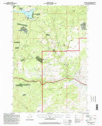
1996 Map of Delmoe Lake
USGS Topo · Published 1998About this map
Delmoe Lake sits at the northern end of this high-elevation landscape within the Deerlodge National Forest. The map documents a rugged terrain shaped by both geologic formations and historic extraction, featuring prominent outcrops like Spire Rock and Pipestone Rock alongside a variety of mineral workings. Evidence of the area's mining history is scattered across the slopes, from the King Mine near McClusky Mountain to the Silver Queen Mine and Marsh Mine. Small residential outposts like Pappas Place and Paul Place are isolated among the timber and rock, while the small settlement of Welch sits along the southern transit corridor. The presence of the Big Pipestone Viaduct and Spire Rock Viaduct indicates the significant engineering required to navigate the steep grades of the Deerlodge mountains, which are further marked by infrastructure like a Runaway Truck Ramp and a utility Pipeline cutting through the forest.
Find a feature on this map
50 named features on this map. Tap any name to fly to it.
Don’t see what you’re looking for? This feature index may not catch every label — zoom into the map to look around manually.
Map Details
Editions of this 1996 Delmoe Lake Map
This is the sole edition of this map. No revisions or reprints were ever made.
Other maps of this area

1889 · Helena
USGS Topo · 1:250,000

1893 · Helena
USGS Topo · 1:250,000

1893 · Dillon
USGS Topo · 1:250,000

1899 · Boulder
USGS Topo · 1:125,000

1899 · Helena
USGS Topo · 1:250,000

1903 · Helena
USGS Topo · 1:250,000

1947 · Butte
USGS Topo · 1:250,000

1954 · Elk Park
USGS Topo · 1:62,500

1954 · Boulder
USGS Topo · 1:62,500

1955 · Dillon
USGS Topo · 1:250,000