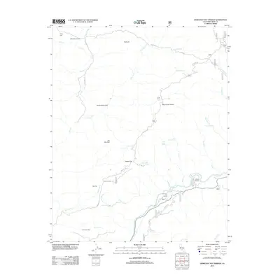
2012 Map of Democrat Hot Springs
USGS Topo · Published 2012About this map
The Kern River carves through the southern portion of this landscape, anchoring the settlement at Democrat Hot Springs and the nearby China Garden. The terrain is defined by dramatic elevation changes from the riverbank to high points like Saturday Peak and Ball Mountain. This 2012 survey captures a network of spring-fed drainages, including Hog Hole Spring, Oscar Meyer Spring, and the Democrat Spring, which historically supported local ranching operations such as French Ranch and Smith Ranch. Higher elevations are marked by the Oak Flat Lookout, providing a clear vantage over the canyon system. The mapping of trails and fire roads, like the Jack Sarret Trl and Democrat Rd, illustrates the modern management of this backcountry area north of the river corridor.
Find a feature on this map
48 named features on this map. Tap any name to fly to it.
Don’t see what you’re looking for? This feature index may not catch every label — zoom into the map to look around manually.
Map Details
Editions of this 2012 Democrat Hot Springs Map
This is the sole edition of this map. No revisions or reprints were ever made.
Other maps of this area

1914 · Caliente
USGS Topo · 1:125,000

1920 · Delonagha
USGS Topo · 1:62,500

1926 · Glennville
USGS Topo · 1:62,500

1932 · Woody
USGS Topo · 1:62,500

1935 · Woody
USGS Topo · 1:62,500

1936 · Tobias Peak
USGS Topo · 1:125,000

1943 · Breckenridge Mountain
USGS Topo · 1:62,500

1943 · Tobias Peak
USGS Topo · 1:125,000

1948 · Bakersfield
USGS Topo · 1:250,000
1952 · Woody
USGS Topo · 1:62,500