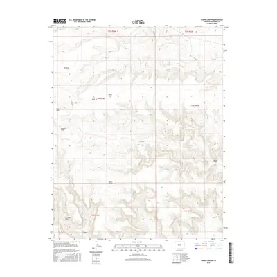
2016 Map of Dennis Canyon
USGS Topo · Published 2016About this map
Mesa de Maya dominates the western portion of this Las Animas County landscape, where the high plains break into a complex system of drainage and relief. The topography is defined by the prominent tablelands of Mid Mesa and Black Mesa, which give way to a network of deeply etched ravines. Waterways like Middle Water Cr and W Carrizo Cr have carved the terrain into distinct landmarks including Sheep Pen Canyon, Miller Canyon, and the namesake Dennis Canyon. This 2016 survey documents a primarily rural and open environment, characterized by section-line tracks and designated county routes such as Co RD 10.8. The map provides a clear record of the area's natural geomorphology and the sparse network of remote roads that facilitate access across these high-altitude mesas and canyons.
Find a feature on this map
21 named features on this map. Tap any name to fly to it.
Don’t see what you’re looking for? This feature index may not catch every label — zoom into the map to look around manually.
Map Details
Editions of this 2016 Dennis Canyon Map
This is the sole edition of this map. No revisions or reprints were ever made.
Other maps of this area

1892 · Mt Carrizo
USGS Topo · 1:125,000

1954 · Dalhart
USGS Topo · 1:250,000

1955 · La Junta
USGS Topo · 1:250,000

1958 · La Junta
USGS Topo · 1:250,000

1958 · Dalhart
USGS Topo · 1:250,000

1962 · Dalhart
USGS Topo · 1:250,000

1968 · La Junta
USGS Topo · 1:250,000
1972 · Wedding Cake Butte
USGS Topo · 1:24,000

1972 · Travesser Park
USGS Topo · 1:24,000
1972 · Tub Spring
USGS Topo · 1:24,000