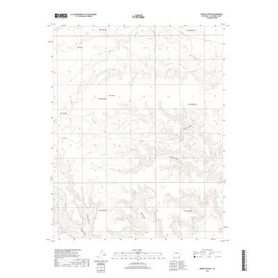
2019 Map of Dennis Canyon
USGS Topo · Published 2019About this map
Mesa de Maya dominates this 2019 survey of the southeastern Colorado landscape, defining the high-relief topography of Las Animas County. The map details a complex network of drainages and tablelands, where watercourses like W Carrizo Cr and Middle Water Cr carve through the arid terrain. The land is largely organized by prominent geologic features, including Mid Mesa and Black Mesa, which stand above a series of deep cuts such as Sheep Pen Canyon and the namesake Dennis Canyon.
Find a feature on this map
21 named features on this map. Tap any name to fly to it.
Don’t see what you’re looking for? This feature index may not catch every label — zoom into the map to look around manually.
Map Details
Editions of this 2019 Dennis Canyon Map
This is the sole edition of this map. No revisions or reprints were ever made.
Other maps of this area

1892 · Mt Carrizo
USGS Topo · 1:125,000

1954 · Dalhart
USGS Topo · 1:250,000

1955 · La Junta
USGS Topo · 1:250,000

1958 · La Junta
USGS Topo · 1:250,000

1958 · Dalhart
USGS Topo · 1:250,000

1962 · Dalhart
USGS Topo · 1:250,000

1968 · La Junta
USGS Topo · 1:250,000
1972 · Wedding Cake Butte
USGS Topo · 1:24,000

1972 · Travesser Park
USGS Topo · 1:24,000
1972 · Tub Spring
USGS Topo · 1:24,000