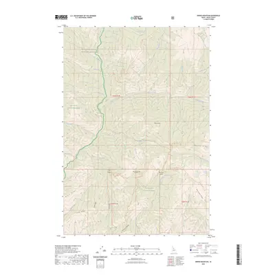
2023 Map of Dennis Mountain
USGS Topo · Published 2023About this map
Frank Church-River of No Return Wilderness and portions of the Nez Perce National Forest and Bitterroot National Forest converge in this high-elevation backcountry. The landscape is defined by its deep drainage networks and prominent ridges, such as Harrington Ridge and Black Ridge. A primary water system, Sabe Creek, flows southward through the northern half of the territory, joined by tributaries like Saddle Creek and Ring Creek.
Find a feature on this map
40 named features on this map. Tap any name to fly to it.
Don’t see what you’re looking for? This feature index may not catch every label — zoom into the map to look around manually.
Map Details
Editions of this 2023 Dennis Mountain Map
This is the sole edition of this map. No revisions or reprints were ever made.
Other maps of this area

1956 · Elk City
USGS Topo · 1:250,000

1960 · Elk City
USGS Topo · 1:250,000

1978 · Waugh Mountain
USGS Topo · 1:24,000

1978 · Arctic Point
USGS Topo · 1:24,000

1978 · Spread Creek Point
USGS Topo · 1:24,000

1978 · Dennis Mtn
USGS Topo · 1:24,000

1978 · Magruder Mtn
USGS Topo · 1:24,000

1978 · Sheep Hill
USGS Topo · 1:24,000

1978 · Devils Teeth Rapids
USGS Topo · 1:24,000
1979 · Sabe Mtn
USGS Topo · 1:24,000