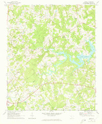
1971 Map of Denny
USGS Topo · Published 1973About this map
Lake Murray dominates the eastern landscape of this Saluda County region, where the Saluda River meets the expanding waters of the reservoir. The topography from the early 1970s reveals a rural landscape defined by narrow creek valleys like Big Creek and Indian Creek, interspersed with small settlements such as Denny and Hickory Grove. A dense network of community centers is evident through the numerous rural houses of worship, including Deans Chapel, Pine Pleasant Ch, and Bethlehem Ch.
Find a feature on this map
21 named features on this map. Tap any name to fly to it.
Don’t see what you’re looking for? This feature index may not catch every label — zoom into the map to look around manually.
Map Details
Editions of this 1971 Denny Map
This is the sole edition of this map. No revisions or reprints were ever made.
Other maps of this area

1941 · Spartanburg
USGS Topo · 1:250,000

1953 · Spartanburg
USGS Topo · 1:250,000

1954 · Augusta
USGS Topo · 1:250,000

1957 · Augusta
USGS Topo · 1:250,000

1958 · Augusta
USGS Topo · 1:250,000

1960 · Spartanburg
USGS Topo · 1:250,000

1961 · Augusta
USGS Topo · 1:250,000

1962 · Augusta
USGS Topo · 1:250,000

1963 · Spartanburg
USGS Topo · 1:250,000

1964 · Spartanburg
USGS Topo · 1:250,000