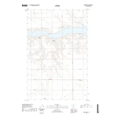
2020 Map of Denson Ranch
USGS Topo · Published 2020About this map
Lake Elwell dominates this northern Montana landscape, its waters filling the deeply carved drainages of the Marias River valley. The surrounding terrain is defined by a series of dramatic coulees, including Marsh Coulee and Hoffman Coulee, which cut through the high plains toward the reservoir. This modern survey reflects a region of large-scale ranching and remote land management, where family-named landmarks like the Denson Ranch anchor the local geography. The section lines of the Public Land Survey System divide the open country, intersected by a network of rural routes such as Dead Indian Rd and Union School Rd. These roads often follow the high ridges between coulees like Dead Indian Coulee, providing essential access to the isolated homesteads and pastures that characterize Toole County's ranching economy in the twenty-first century.
Find a feature on this map
17 named features on this map. Tap any name to fly to it.
Don’t see what you’re looking for? This feature index may not catch every label — zoom into the map to look around manually.
Map Details
Editions of this 2020 Denson Ranch Map
This is the sole edition of this map. No revisions or reprints were ever made.
Other maps of this area

1920 · Conrad
USGS Topo · 1:125,000

1954 · Shelby
USGS Topo · 1:250,000

1958 · Shelby
USGS Topo · 1:250,000

1967 · Central School
USGS Topo · 1:24,000

1967 · South Devon School
USGS Topo · 1:24,000
1967 · Fowler Coulee NE
USGS Topo · 1:24,000

1970 · Knees NE
USGS Topo · 1:24,000

1970 · Sollid School
USGS Topo · 1:24,000

1970 · Pondera School
USGS Topo · 1:24,000

1970 · Devon
USGS Topo · 1:24,000