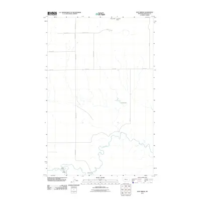
2011 Map of Dent Bridge
USGS Topo · Published 2011About this map
The Teton River carves a winding path through this corner of Chouteau County, where the landscape is defined by its drainages and higher elevations like Hay Stack Butte and Straw Stack. Transport in this part of Montana follows a geometric grid of local routes such as School House Rd and Collins Rd, contrasted by more organic paths like Rattlesnake Trl and Long Trl. The map centers on the Dent Bridge crossing, a critical point of connectivity over the river. Significant local terrain features including Alkali Coulee and Berry Coulee show the erosion patterns of the northern plains. A unique man-made feature, the Incorporeal Dam, sits isolated north of the river, suggesting the critical importance of water management in this agricultural and ranching environment.
Find a feature on this map
15 named features on this map. Tap any name to fly to it.
Don’t see what you’re looking for? This feature index may not catch every label — zoom into the map to look around manually.
Map Details
Editions of this 2011 Dent Bridge Map
This is the sole edition of this map. No revisions or reprints were ever made.
Other maps of this area

1886 · Great Falls
USGS Topo · 1:250,000

1949 · Timber Coulee
USGS Topo · 1:62,500

1950 · Timber Coulee
USGS Topo · 1:62,500

1950 · Dent Bridge
USGS Topo · 1:62,500

1954 · Great Falls
USGS Topo · 1:250,000

1954 · Shelby
USGS Topo · 1:250,000

1957 · Great Falls
USGS Topo · 1:250,000

1958 · Shelby
USGS Topo · 1:250,000
1965 · Sheep Coulee Spring
USGS Topo · 1:24,000

1970 · Knees
USGS Topo · 1:24,000