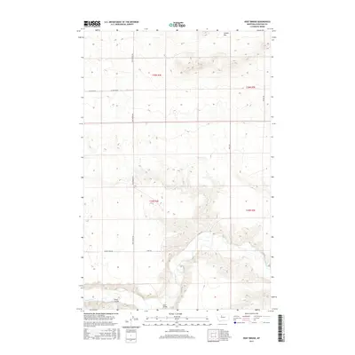
2017 Map of Dent Bridge
USGS Topo · Published 2017About this map
The Teton River winds through the southern reaches of this Chouteau County landscape, joined by the drainage of Alkali Coulee near the namesake settlement of Dent Bridge. This high plains terrain is defined by a series of plateaus and flats, most notably Sample Flat in the northeast, where the elevation rises significantly above the river valley. The map documents a sparse but vital network of early 21st-century rural transit, including the north-south artery of Dent Bridge Rd and the long, overland route of Long Trl.
Find a feature on this map
13 named features on this map. Tap any name to fly to it.
Don’t see what you’re looking for? This feature index may not catch every label — zoom into the map to look around manually.
Map Details
Editions of this 2017 Dent Bridge Map
This is the sole edition of this map. No revisions or reprints were ever made.
Other maps of this area

1886 · Great Falls
USGS Topo · 1:250,000

1949 · Timber Coulee
USGS Topo · 1:62,500

1950 · Timber Coulee
USGS Topo · 1:62,500

1950 · Dent Bridge
USGS Topo · 1:62,500

1954 · Great Falls
USGS Topo · 1:250,000

1954 · Shelby
USGS Topo · 1:250,000

1957 · Great Falls
USGS Topo · 1:250,000

1958 · Shelby
USGS Topo · 1:250,000
1965 · Sheep Coulee Spring
USGS Topo · 1:24,000

1970 · Knees
USGS Topo · 1:24,000