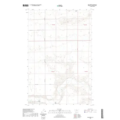
2020 Map of Dent Bridge
USGS Topo · Published 2020About this map
The Teton River carves a deep, winding path through the heart of this Chouteau County landscape, creating a stark contrast with the high, dry plateaus above. The namesake Dent Bridge serves as a critical crossing point, connecting remote ranchlands via Dent Bridge Rd. This region is defined by its dramatic drainage patterns, where features like Alkali Coulee feed into the river valley. The map reveals a systematic grid of land management and transportation, with long thoroughfares such as Mcauthur Rd and Russell Rd traversing the open range. In the northern reaches, the terrain levels out at Sample Flat, illustrating the transition from the river's broken breaks to the expansive benchlands of central Montana. Historical paths like Long Trl follow the natural contours of the ridges, while Prairie View Rd provides access across the central plains.
Find a feature on this map
13 named features on this map. Tap any name to fly to it.
Don’t see what you’re looking for? This feature index may not catch every label — zoom into the map to look around manually.
Map Details
Editions of this 2020 Dent Bridge Map
This is the sole edition of this map. No revisions or reprints were ever made.
Other maps of this area

1886 · Great Falls
USGS Topo · 1:250,000

1949 · Timber Coulee
USGS Topo · 1:62,500

1950 · Timber Coulee
USGS Topo · 1:62,500

1950 · Dent Bridge
USGS Topo · 1:62,500

1954 · Great Falls
USGS Topo · 1:250,000

1954 · Shelby
USGS Topo · 1:250,000

1957 · Great Falls
USGS Topo · 1:250,000

1958 · Shelby
USGS Topo · 1:250,000
1965 · Sheep Coulee Spring
USGS Topo · 1:24,000

1970 · Knees
USGS Topo · 1:24,000