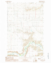
1987 Map of Dent Bridge
USGS Topo · Published 1987About this map
The Teton River carves a deep, winding course through the landscape of Chouteau County, creating a stark contrast between the alluvial floor and the surrounding high plains. Near the southern edge of this 1987 survey, the Dent Bridge provides a vital crossing point over the river, serving as a primary landmark in an otherwise sparsely settled ranching and grazing region. The map captures a moment in the late 20th century before significant modern development, where the land use is defined by extractive industry and resource management.
Find a feature on this map
7 named features on this map. Tap any name to fly to it.
Don’t see what you’re looking for? This feature index may not catch every label — zoom into the map to look around manually.
Map Details
Editions of this 1987 Dent Bridge Map
This is the sole edition of this map. No revisions or reprints were ever made.
Other maps of this area

1886 · Great Falls
USGS Topo · 1:250,000

1949 · Timber Coulee
USGS Topo · 1:62,500

1950 · Timber Coulee
USGS Topo · 1:62,500

1950 · Dent Bridge
USGS Topo · 1:62,500

1954 · Great Falls
USGS Topo · 1:250,000

1954 · Shelby
USGS Topo · 1:250,000

1957 · Great Falls
USGS Topo · 1:250,000

1958 · Shelby
USGS Topo · 1:250,000
1965 · Sheep Coulee Spring
USGS Topo · 1:24,000

1970 · Knees
USGS Topo · 1:24,000