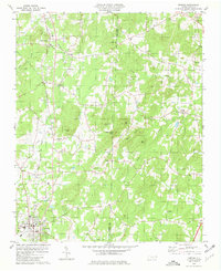
1980 Map of Denton
USGS Topo · Published 1981About this map
The town of Denton serves as the focal point for this survey of south-central Davidson County, where the Highpoint Thomasville and Denton railroad line dictates the local transportation geography. The landscape is characterized by a series of prominent peaks, including Crouse Mtn, Prickly Pear Mtn, and Steep Rock Mtn, which separate the various creek drainage basins. These watersheds, such as Flat Swamp Creek and Jackson Creek, are dotted with a dense network of country churches that form the backbone of the rural community.
Find a feature on this map
41 named features on this map. Tap any name to fly to it.
Don’t see what you’re looking for? This feature index may not catch every label — zoom into the map to look around manually.
Map Details
Editions of this 1980 Denton Map
This is the sole edition of this map. No revisions or reprints were ever made.
Other maps of this area

1949 · High Rock
USGS Topo · 1:24,000

1949 · Denton NW
USGS Topo · 1:24,000

1950 · Lexington East
USGS Topo · 1:24,000

1951 · Lexington East
USGS Topo · 1:24,000

1951 · Fair Grove
USGS Topo · 1:24,000

1953 · Raleigh
USGS Topo · 1:250,000

1953 · Charlotte
USGS Topo · 1:250,000

1954 · Charlotte
USGS Topo · 1:250,000

1954 · Raleigh
USGS Topo · 1:250,000

1957 · Denton
USGS Topo · 1:62,500