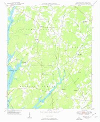
1949 Map of Denton NW
USGS Topo · Published 1949About this map
The waters of High Rock Lake define the western edge of this 1949 survey, where the Winston-Salem Southbound railroad skirts the shoreline near Cotton Grove. Moving inland from the lake, the landscape transitions into the hills of Silver Hill, Emmons, and Healing Spring, areas marked by a network of small creeks and branches.
Find a feature on this map
28 named features on this map. Tap any name to fly to it.
Don’t see what you’re looking for? This feature index may not catch every label — zoom into the map to look around manually.
Map Details
Editions of this 1949 Denton NW Map
2 editions found
Other maps of this area

1949 · High Rock
USGS Topo · 1:24,000

1949 · Denton NW
USGS Topo · 1:24,000

1950 · Lexington East
USGS Topo · 1:24,000

1950 · Lexington West
USGS Topo · 1:24,000

1951 · Lexington East
USGS Topo · 1:24,000

1951 · Lexington West
USGS Topo · 1:24,000

1951 · Fair Grove
USGS Topo · 1:24,000

1953 · Charlotte
USGS Topo · 1:250,000

1954 · Charlotte
USGS Topo · 1:250,000

1957 · Denton
USGS Topo · 1:62,500