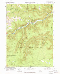
1969 Map of Dents Run
USGS Topo · Published 1973About this map
Sinnemahoning Creek and the Bennett Branch converge in this rugged section of the Pennsylvania Wilds, where heavy industry meets deep timberlands. The landscape of the late 1960s is defined by a mix of extraction and conservation, with active strip mines dotting Winslow Hill while the surrounding territory is managed as the Elk State Forest and Moshannon State Forest. Small settlements like Wilmer and Summerson represent the human footprint in the narrow valleys, alongside the high-elevation Johnson Cem. The rail-dominated transport network of the era is anchored by the Penn Central line following the river curves, providing a critical corridor through the mountainous terrain. Notable landmarks such as a Lookout Tower and Radio Tower emphasize the ridge-top observation points essential for fire monitoring and communication in this forested expanse.
Find a feature on this map
46 named features on this map. Tap any name to fly to it.
Don’t see what you’re looking for? This feature index may not catch every label — zoom into the map to look around manually.
Map Details
Editions of this 1969 Dents Run Map
3 editions found
Other maps of this area

1929 · Karthaus
USGS Topo · 1:62,500

1929 · Clearfield
USGS Topo · 1:48,000

1932 · Clearfield
USGS Topo · 1:62,500

1932 · Karthaus
USGS Topo · 1:62,500

1941 · Benezette
USGS Topo · 1:62,500

1943 · Benezette
USGS Topo · 1:62,500

1945 · Driftwood
USGS Topo · 1:48,000

1945 · Driftwood
USGS Topo · 1:24,000

1945 · Cameron
USGS Topo · 1:24,000

1947 · Cameron
USGS Topo · 1:24,000
Featured Places
- Benezette Township, PA
- Gibson Township, PA
- Grant, Benezette Township
- Wilmer, Benezette Township
- Sumerson, Benezette Township