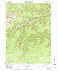
1969 Map of Dents Run
USGS Topo · Published 1982About this map
Sinnemahoning Creek Branch Bennett serves as the primary drainage and transit corridor through this section of the Pennsylvania wilds, followed closely by the Conrail rail line. The small settlements of Grant and Summerson cling to the riverbanks, while the surrounding high country of Winslow Hill and Grant Hill is dominated by the sprawling acreage of Elk State Forest and Moshannon State Forest.
Find a feature on this map
59 named features on this map. Tap any name to fly to it.
Don’t see what you’re looking for? This feature index may not catch every label — zoom into the map to look around manually.
Map Details
Editions of this 1969 Dents Run Map
3 editions found
Other maps of this area

1929 · Karthaus
USGS Topo · 1:62,500

1929 · Clearfield
USGS Topo · 1:48,000

1932 · Clearfield
USGS Topo · 1:62,500

1932 · Karthaus
USGS Topo · 1:62,500

1941 · Benezette
USGS Topo · 1:62,500

1943 · Benezette
USGS Topo · 1:62,500

1945 · Driftwood
USGS Topo · 1:48,000

1945 · Driftwood
USGS Topo · 1:24,000

1945 · Cameron
USGS Topo · 1:24,000

1947 · Cameron
USGS Topo · 1:24,000
Featured Places
- Benezette Township, PA
- Gibson Township, PA
- Grant, Benezette Township
- Wilmer, Benezette Township
- Sumerson, Benezette Township