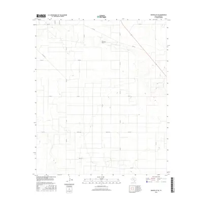
2016 Map of Denver City SE
USGS Topo · Published 2016About this map
Wardswell Draw cuts across the northern landscape of this Gaines County region, serving as a primary drainage feature in an area defined by its systematic grid of rural roads and ranch infrastructure. This 2016 survey by the U.S. Geological Survey illustrates the modern organization of the Texas High Plains, where expansive agricultural and ranching tracts are partitioned by a network of county routes. A significant transportation corridor is formed by Ranch Rd 1757 and its associated segments, Fm 1757 and Fr 1757, which anchor the southern and western portions of the quadrangle. The map details a landscape transition where established roads like Co Rd 218 and Co Rd 225 connect isolated sites across the semi-arid terrain, providing essential context for understanding contemporary land use and property boundaries in this part of West Texas.
Find a feature on this map
18 named features on this map. Tap any name to fly to it.
Don’t see what you’re looking for? This feature index may not catch every label — zoom into the map to look around manually.
Map Details
Editions of this 2016 Denver City SE Map
This is the sole edition of this map. No revisions or reprints were ever made.
Other maps of this area

1954 · Hobbs
USGS Topo · 1:250,000

1958 · Hobbs
USGS Topo · 1:250,000

1970 · Seagraves SW
USGS Topo · 1:24,000

1970 · Seagraves NW
USGS Topo · 1:24,000

1970 · Seminole
USGS Topo · 1:24,000

1971 · Paynes Corner
USGS Topo · 1:24,000

1971 · Higginbotham
USGS Topo · 1:24,000
1971 · Denver City
USGS Topo · 1:24,000

1971 · Denver City SW
USGS Topo · 1:24,000
1971 · Paynes Corner NW
USGS Topo · 1:24,000