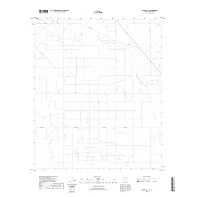
2019 Map of Denver City SE
USGS Topo · Published 2019About this map
Wardswell Draw meanders through the arid landscape of Gaines County, forming the primary natural drainage feature in this corner of the Llano Estacado. The terrain is defined by its agricultural and industrial layout, evidenced by the dense grid of rural roads and section lines characteristic of West Texas. Major corridors such as Ranch Rd 1757 and FM 1757 facilitate movement across the territory, connecting remote operations and farmsteads. Smaller routes like Co Rd 218 and Co Rd 220 weave between numerous depressions and localized basins, which often serve as vital catchment areas in this high plains environment. The map captures a moment of modern land management where the traditional ranching grid intersects with the infrastructure needed for regional connectivity and resource access.
Find a feature on this map
18 named features on this map. Tap any name to fly to it.
Don’t see what you’re looking for? This feature index may not catch every label — zoom into the map to look around manually.
Map Details
Editions of this 2019 Denver City SE Map
This is the sole edition of this map. No revisions or reprints were ever made.
Other maps of this area

1954 · Hobbs
USGS Topo · 1:250,000

1958 · Hobbs
USGS Topo · 1:250,000

1970 · Seagraves SW
USGS Topo · 1:24,000

1970 · Seagraves NW
USGS Topo · 1:24,000

1970 · Seminole
USGS Topo · 1:24,000

1971 · Paynes Corner
USGS Topo · 1:24,000

1971 · Higginbotham
USGS Topo · 1:24,000
1971 · Denver City
USGS Topo · 1:24,000

1971 · Denver City SW
USGS Topo · 1:24,000
1971 · Paynes Corner NW
USGS Topo · 1:24,000