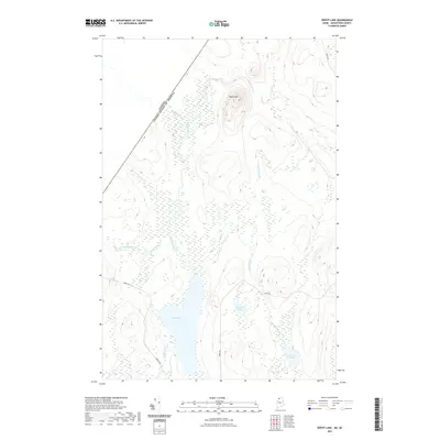
2021 Map of Depot Lake
USGS Topo · Published 2021About this map
The international boundary between the Canada and the United States defines the northwestern corner of this remote Aroostook County landscape. Dominated by a dense network of waterways, the area centers on Depot Lake and the prominent rising elevation of Depot Mtn. A complex system of streams and wetlands, including Depot Stream, Cunliffe Brook, and Dead Brook, feeds the larger water bodies and illustrates the natural drainage patterns of this North Woods region. The minimal road infrastructure, consisting of routes like Depot Rd, Labrie Rd, and Labrie Blvd, suggests a landscape primarily shaped by timber interests and backcountry access. This survey preserves the topographical details of landforms around Cunliffe Pond and Linscott Pond at the start of the 2020s, providing a clear record of the territory just east of the Quebec border.
Find a feature on this map
15 named features on this map. Tap any name to fly to it.
Don’t see what you’re looking for? This feature index may not catch every label — zoom into the map to look around manually.
Map Details
Editions of this 2021 Depot Lake Map
This is the sole edition of this map. No revisions or reprints were ever made.
Other maps of this area

1954 · Presque Isle
USGS Topo · 1:250,000

1955 · Depot Lake
USGS Topo · 1:62,500

1955 · Beaver Pond
USGS Topo · 1:62,500

1955 · Clayton Lake
USGS Topo · 1:62,500

1955 · Seven Islands
USGS Topo · 1:62,500

1958 · Presque Isle
USGS Topo · 1:250,000

1960 · Presque Isle
USGS Topo · 1:250,000

1976 · Depot Lake
USGS Topo · 1:24,000
1976 · St. Pamphile
USGS Topo · 1:24,000
1977 · St. Adalbert
USGS Topo · 1:24,000