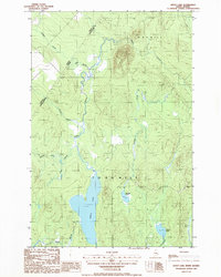
1986 Map of Depot Lake
USGS Topo · Published 1986About this map
Depot Lake dominates this remote stretch of the North Maine Woods, situated just across the international border from L'Islet Co, Quebec. The landscape is defined by a dense network of waterways feeding into the south-flowing Depot Stream, which meanders through wetlands and receives tributaries like Dead Brook and Brown Brook. The 1980s terrain shows a wilderness primarily used for timber management and resource extraction, evidenced by the presence of a Gravel Pit and numerous unimproved roads and trails cutting through the forest. Small bodies of water such as Cunliffe Pond and Linscott Pond punctuate the topography near Ninemile Bk. This survey captures the borderlands of Aroostook Co at a time when the area remained largely uninhabited, focused on the logging industry and the natural drainage patterns of the upper Saint John River watershed.
Find a feature on this map
17 named features on this map. Tap any name to fly to it.
Don’t see what you’re looking for? This feature index may not catch every label — zoom into the map to look around manually.
Map Details
Editions of this 1986 Depot Lake Map
This is the sole edition of this map. No revisions or reprints were ever made.
Other maps of this area

1954 · Presque Isle
USGS Topo · 1:250,000

1955 · Depot Lake
USGS Topo · 1:62,500

1955 · Beaver Pond
USGS Topo · 1:62,500

1955 · Clayton Lake
USGS Topo · 1:62,500

1955 · Seven Islands
USGS Topo · 1:62,500

1958 · Presque Isle
USGS Topo · 1:250,000

1960 · Presque Isle
USGS Topo · 1:250,000

1976 · Depot Lake
USGS Topo · 1:24,000
1976 · St. Pamphile
USGS Topo · 1:24,000
1977 · St. Adalbert
USGS Topo · 1:24,000