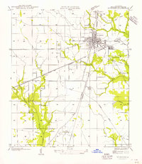
1956 Map of DeRidder
USGS Topo · Published 1956About this map
De Ridder serves as the central hub for this mid-century western Louisiana landscape, where the convergence of several major rail lines defined the regional economy. The Kansas City Southern, Southern Pacific, and Gulf Colorado and Santa Fe railroads crisscross the parish, supporting timber and agricultural interests. Evidence of the area's industrial past is visible through multiple segments of Old Logging Railroad Grade that branch into the surrounding timberlands near Ludington and Carson. Small rural centers such as Grabow and Bon Ami appear alongside local landmarks like Pine Ridge Ch and Old Hickman Sch. The terrain is defined by a dense network of waterways, including Hickory Branch and Cowpen Creek, which shaped the early development of these Beauregard Parish communities.
Find a feature on this map
27 named features on this map. Tap any name to fly to it.
Don’t see what you’re looking for? This feature index may not catch every label — zoom into the map to look around manually.
Map Details
Editions of this 1956 DeRidder Map
This is the sole edition of this map. No revisions or reprints were ever made.
Other maps of this area

1947 · Singer
USGS Topo · 1:31,680

1947 · Pujo
USGS Topo · 1:31,680

1947 · DeRidder
USGS Topo · 1:31,680

1947 · Rosepine
USGS Topo · 1:31,680

1947 · Knight
USGS Topo · 1:31,680

1947 · Ikes
USGS Topo · 1:31,680

1947 · Chasmore
USGS Topo · 1:31,680

1947 · Beckwith School
USGS Topo · 1:31,680

1947 · Bannister
USGS Topo · 1:31,680

1952 · Lake Charles
USGS Topo · 1:250,000