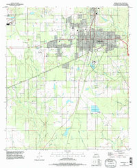
1984 Map of Deridder
USGS Topo · Published 1997About this map
Deridder serves as the central hub of this 1980s landscape, where the urban grid meets the piney woods and creek bottoms of Louisiana. The map reveals a community defined by its logistical infrastructure, featuring the Beauregard Parish Airport and the smaller Swamp Smith Landing Strip to the southeast. Waterways like Hickory Branch and Palmetto Creek carve through the terrain, while peripheral settlements such as Bon Ami, Hite, and Carson suggest the area's historical footprint beyond the main city limits. The presence of several Gravel Pit locations and a Filtration Plant indicates an economy tied to natural resource extraction and municipal utility development. This era of Beauregard Parish shows a transition toward modern aviation and residential expansion, evidenced by the multiple Mobile Home Park designations clustered near the city and the northern Golf Course.
Find a feature on this map
31 named features on this map. Tap any name to fly to it.
Don’t see what you’re looking for? This feature index may not catch every label — zoom into the map to look around manually.
Map Details
Editions of this 1984 Deridder Map
This is the sole edition of this map. No revisions or reprints were ever made.
Other maps of this area

1947 · Singer
USGS Topo · 1:31,680

1947 · Pujo
USGS Topo · 1:31,680

1947 · DeRidder
USGS Topo · 1:31,680

1947 · Rosepine
USGS Topo · 1:31,680

1947 · Knight
USGS Topo · 1:31,680

1947 · Ikes
USGS Topo · 1:31,680

1947 · Chasmore
USGS Topo · 1:31,680

1947 · Beckwith School
USGS Topo · 1:31,680

1947 · Bannister
USGS Topo · 1:31,680

1952 · Lake Charles
USGS Topo · 1:250,000