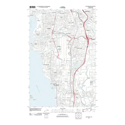
2011 Map of Des Moines
USGS Topo · Published 2011About this map
Pugent Sound defines the western edge of this coastal landscape, where the saltwater shoreline meets a dense network of suburban development and critical transportation infrastructure. The massive footprint of Seattle-Tacoma International Airport dominates the center of the sheet, surrounded by the established communities of Burien, SeaTac, and Des Moines. To the east, the Duwamish River and Green River meander through industrial corridors near Tukwila, accompanied by the BNSF Railway and major highway interchanges. The map reveals the civic and recreational character of the South Sound through features like the Des Moines Marina and numerous cemeteries, including Washington Memorial Park and Riverton Crest Cemetery. Small inland water bodies such as Angle Lake and Bow Lake are preserved amidst the grid of residential streets and post offices that service neighborhoods like Sunnydale and Zenith.
Find a feature on this map
134 named features on this map. Tap any name to fly to it.
Don’t see what you’re looking for? This feature index may not catch every label — zoom into the map to look around manually.
Map Details
Editions of this 2011 Des Moines Map
This is the sole edition of this map. No revisions or reprints were ever made.
Other maps of this area

1894 · Seattle
USGS Topo · 1:62,500

1895 · Snohomish
USGS Topo · 1:125,000

1897 · Tacoma
USGS Topo · 1:125,000

1897 · Seattle
USGS Topo · 1:125,000

1900 · Tacoma
USGS Topo · 1:125,000

1908 · Seattle
USGS Topo · 1:62,500

1909 · Seattle Special
USGS Topo · 1:62,500

1949 · Tacoma North
USGS Topo · 1:24,000

1949 · Poverty Bay
USGS Topo · 1:24,000

1949 · Renton
USGS Topo · 1:24,000