
1949 Map of Tacoma North
USGS Topo · Published 1956About this map
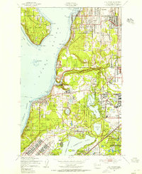
The industrial heartbeat of Tacoma and its maritime approaches are captured in this mid-century survey, detailing the complex network of waterways that define the Port of Tacoma. From the Hylebos Waterway to the Middle Waterway, the map illustrates a landscape transformed by commerce and naval requirements, including the U S Navy Shipyard. This era shows the city’s established educational anchors, such as the College of Puget Sound, Stadium High Sch, and the Annie Wright Seminary, situated on the bluffs overlooking Commencement Bay.
Find a feature on this map
59 named features on this map. Tap any name to fly to it.
Don’t see what you’re looking for? This feature index may not catch every label — zoom into the map to look around manually.
Map Details
Editions of this 1949 Tacoma North Map
This is the sole edition of this map. No revisions or reprints were ever made.
Other maps of this area

1897 · Tacoma
USGS Topo · 1:125,000

1900 · Tacoma
USGS Topo · 1:125,000

1940 · Anderson Island
USGS Topo · 1:62,500

1941 · Tacoma South
USGS Topo · 1:62,500

1942 · Gig Harbor
USGS Topo · 1:62,500

1943 · Gig Harbor
USGS Topo · 1:62,500

1944 · Tacoma South
USGS Topo · 1:62,500

1948 · Anderson Island
USGS Topo · 1:62,500
1948 · Steilacoom
USGS Topo · 1:24,000

1949 · Poverty Bay
USGS Topo · 1:24,000