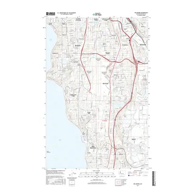
2017 Map of Des Moines
USGS Topo · Published 2017About this map
Seatac and the sprawling Seattle-Tacoma International Airport dominate the central landscape of this King County survey, illustrating the massive scale of modern aviation infrastructure. Along the eastern edge, the industrial and commercial corridors of Tukwila and Kent follow the path of the Green River, intersected by major arteries like International Blvd and Military Rd S. To the west, the residential patterns of Burien, Normandy Park, and Des Moines slope toward the Puget Sound shoreline, where points like Seola Beach and Des Moines Beach meet the water.
Find a feature on this map
80 named features on this map. Tap any name to fly to it.
Don’t see what you’re looking for? This feature index may not catch every label — zoom into the map to look around manually.
Map Details
Editions of this 2017 Des Moines Map
This is the sole edition of this map. No revisions or reprints were ever made.
Other maps of this area

1894 · Seattle
USGS Topo · 1:62,500

1895 · Snohomish
USGS Topo · 1:125,000

1897 · Tacoma
USGS Topo · 1:125,000

1897 · Seattle
USGS Topo · 1:125,000

1900 · Tacoma
USGS Topo · 1:125,000

1908 · Seattle
USGS Topo · 1:62,500

1909 · Seattle Special
USGS Topo · 1:62,500
1949 · Tacoma North
USGS Topo · 1:24,000
1949 · Poverty Bay
USGS Topo · 1:24,000
1949 · Renton
USGS Topo · 1:24,000