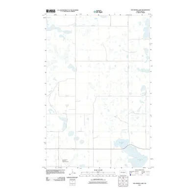
2011 Map of Des Moines Lake
USGS Topo · Published 2011About this map
Des Moines Lake and Sink Lake define the hydrology of this prairie landscape in Kidder County. The terrain is marked by numerous seasonal wetlands and small basins typical of the Missouri Coteau region. Human infrastructure is primarily organized around the Public Land Survey System, with gravel roads like 18th St SE and 40th Ave SE following section lines to serve remote farmsteads and agricultural tracts. A notable modern addition to this rural township is the Lake Williams Township Municipal Airport, which sits near the intersection of 36th Ave SE and 20th St SE. This 2011 survey captures the area's transition between traditional ranching land and specialized rural services, where large water bodies remain the most prominent landmarks in an otherwise open, gridded expanse.
Find a feature on this map
15 named features on this map. Tap any name to fly to it.
Don’t see what you’re looking for? This feature index may not catch every label — zoom into the map to look around manually.
Map Details
Editions of this 2011 Des Moines Lake Map
This is the sole edition of this map. No revisions or reprints were ever made.
Other maps of this area

1952 · New Rockford
USGS Topo · 1:250,000

1956 · New Rockford
USGS Topo · 1:250,000

1971 · New Rockford
USGS Topo · 1:250,000

1972 · Kunkel Lake
USGS Topo · 1:24,000
1972 · Horsehead Lake
USGS Topo · 1:24,000

1972 · Lake Williams
USGS Topo · 1:24,000

1972 · Robinson
USGS Topo · 1:24,000
1972 · Pettibone
USGS Topo · 1:24,000

1972 · Des Moines Lake
USGS Topo · 1:24,000

1978 · Wagon Wheel Hill
USGS Topo · 1:24,000