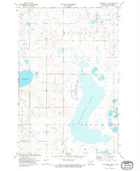
1972 Map of Horsehead Lake
USGS Topo · Published 1974About this map
Horsehead Lake dominates this central North Dakota landscape, its irregular shoreline defining the local topography in the early 1970s. The map illustrates a region heavily focused on conservation and water management, highlighted by the extensive Horsehead Lake State Game Management Area and the National Waterfowl Production Area situated along the eastern margins. These protected lands emphasize the area's importance as a prairie pothole habitat, characterized by numerous smaller depressions and wetlands scattered between Clear Lake and Cherry Lake.
Find a feature on this map
11 named features on this map. Tap any name to fly to it.
Don’t see what you’re looking for? This feature index may not catch every label — zoom into the map to look around manually.
Map Details
Editions of this 1972 Horsehead Lake Map
This is the sole edition of this map. No revisions or reprints were ever made.
Other maps of this area

1952 · Tappen North
USGS Topo · 1:24,000

1952 · Steele NE
USGS Topo · 1:24,000

1952 · Steele NW
USGS Topo · 1:24,000

1952 · New Rockford
USGS Topo · 1:250,000

1953 · Jamestown
USGS Topo · 1:250,000

1956 · New Rockford
USGS Topo · 1:250,000

1956 · Jamestown
USGS Topo · 1:250,000

1971 · New Rockford
USGS Topo · 1:250,000

1972 · Tuttle
USGS Topo · 1:24,000

1972 · Kunkel Lake
USGS Topo · 1:24,000