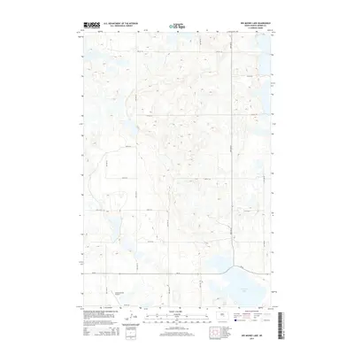
2014 Map of Des Moines Lake
USGS Topo · Published 2014About this map
Des Moines Lake and the smaller, nearby Sink Lake anchor this glaciated prairie landscape in Kidder County. The terrain is defined by numerous unnamed prairie potholes and depressions typical of the Missouri Coteau region, which influence the local road network. A rigid grid of section lines, including 37th Ave SE and 17th St SE, organizes the agricultural surroundings. Transportation in the southern portion of the quadrangle is facilitated by ND-36, which passes just north of Whitman Field Airport. This airfield serves as a primary point of interest in an otherwise sparsely populated area dominated by seasonal wetlands and large-scale farming tracts.
Find a feature on this map
19 named features on this map. Tap any name to fly to it.
Don’t see what you’re looking for? This feature index may not catch every label — zoom into the map to look around manually.
Map Details
Editions of this 2014 Des Moines Lake Map
This is the sole edition of this map. No revisions or reprints were ever made.
Other maps of this area

1952 · New Rockford
USGS Topo · 1:250,000

1956 · New Rockford
USGS Topo · 1:250,000

1971 · New Rockford
USGS Topo · 1:250,000

1972 · Kunkel Lake
USGS Topo · 1:24,000
1972 · Horsehead Lake
USGS Topo · 1:24,000

1972 · Lake Williams
USGS Topo · 1:24,000

1972 · Robinson
USGS Topo · 1:24,000
1972 · Pettibone
USGS Topo · 1:24,000

1972 · Des Moines Lake
USGS Topo · 1:24,000

1978 · Wagon Wheel Hill
USGS Topo · 1:24,000