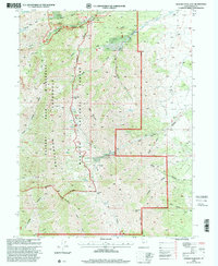
1998 Map of Deseret Peak East
USGS Topo · Published 2001About this map
Stansbury Mountains topography dominates this late-1990s revision of the Deseret Peak area. The landscape is a complex network of high-altitude drainages, including Cedar Canyon and Hickman Canyon, within the Wasatch National Forest. The map documents a significant intersection of recreational and natural resource management, clearly delineating the Stansbury Mountains Wilderness boundary. A string of developed sites along South Willow Creek provides a look at the region's managed infrastructure, featuring the South Willow Adm Site and several designated areas like Intake Campground and Boy Scout Campground. For those tracing local landmarks, the map identifies high-country waters such as North Willow Lake and numerous vital springs, including Cold Spring and Stradley Spring, which have long supported activity in this arid high-elevation environment.
Find a feature on this map
67 named features on this map. Tap any name to fly to it.
Don’t see what you’re looking for? This feature index may not catch every label — zoom into the map to look around manually.
Map Details
Editions of this 1998 Deseret Peak East Map
This is the sole edition of this map. No revisions or reprints were ever made.
Other maps of this area

1885 · Tooele Valley
USGS Topo · 1:250,000

1918 · Stockton
USGS Topo · 1:62,500

1953 · Tooele
USGS Topo · 1:250,000

1955 · Timpie
USGS Topo · 1:62,500

1955 · Deseret Peak
USGS Topo · 1:62,500

1955 · Grantsville
USGS Topo · 1:24,000

1955 · Stockton
USGS Topo · 1:62,500

1955 · Tooele
USGS Topo · 1:250,000

1979 · Rush Valley
USGS Topo · 1:100,000
1979 · Tooele
USGS Topo · 1:100,000