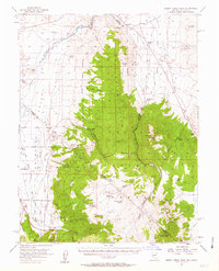
1956 Map of Desert Creek Peak
USGS Topo · Published 1963About this map
Desert Creek Peak dominates the center of this high-elevation terrain, marking a dramatic landscape where the Wellington Hills rise above the agricultural valley floor. The map records the complex water management systems essential to the region, including the Saroni Canal, Smith Valley Canal, and Eastside Canal, which divert the Walker River to sustain scattered outposts like the Rosaschi Ranch. Evidence of the area's mining history is scattered throughout the hills, from the Boulder Hill Mine in the north to the Rickey Mine further south.
Find a feature on this map
70 named features on this map. Tap any name to fly to it.
Don’t see what you’re looking for? This feature index may not catch every label — zoom into the map to look around manually.
Map Details
Editions of this 1956 Desert Creek Peak Map
3 editions found

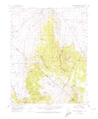
Other maps of this area

1889 · Markleeville
USGS Topo · 1:125,000

1891 · Markleeville
USGS Topo · 1:125,000

1891 · Wellington
USGS Topo · 1:125,000

1893 · Markleeville
USGS Topo · 1:125,000

1893 · Wellington
USGS Topo · 1:125,000

1896 · Dardanelles
USGS Topo · 1:125,000

1898 · Dardanelles
USGS Topo · 1:125,000

1909 · Bridgeport
USGS Topo · 1:125,000

1911 · Bridgeport
USGS Topo · 1:125,000

1920 · Bridgeport
USGS Topo · 1:125,000