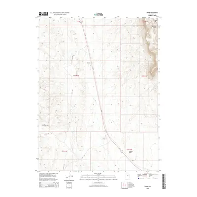
2014 Map of Desert
USGS Topo · Published 2014About this map
Gunnison Valley and the towering heights of the Book Cliffs dominate this portion of Emery County, where the high desert meets steep escarpments. The landscape is defined by its drainage systems, including the long paths of Cottonwood Wash and Lost Spring Wash, which carve through the arid terrain. The map captures the transit corridor of Us-191 as it runs north-south, passing the small locality of Desert. In the northeastern corner, the elevation rises sharply toward Middle Mtn and the complex geography of Blue Castle Canyon. This survey illustrates the sparse settlement patterns typical of this region in the early 21st century, where large stretches of land remain undeveloped except for service roads like Buckmaster Rd and various county routes that connect isolated landmarks such as Trail Spring and the southern point at Sphinx.
Find a feature on this map
19 named features on this map. Tap any name to fly to it.
Don’t see what you’re looking for? This feature index may not catch every label — zoom into the map to look around manually.
Map Details
Editions of this 2014 Desert Map
This is the sole edition of this map. No revisions or reprints were ever made.
Other maps of this area

1885 · San Rafael
USGS Topo · 1:250,000

1886 · Price River
USGS Topo · 1:250,000

1896 · Price River
USGS Topo · 1:250,000

1953 · Beckwith Peak SW
USGS Topo · 1:24,000

1953 · Tidwell 2 NW
USGS Topo · 1:24,000

1954 · Tidwell 2 NE
USGS Topo · 1:24,000

1954 · Tidwell 1 NW
USGS Topo · 1:24,000

1954 · Tidwell Bottoms
USGS Topo · 1:62,500

1954 · Green River
USGS Topo · 1:62,500

1956 · Salina
USGS Topo · 1:250,000