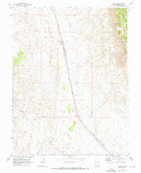
1969 Map of Desert
USGS Topo · Published 1973About this map
The Denver and Rio Grande Western railroad corridor dictates the settlement pattern of this arid Emery County landscape as it appeared in the late 1960s. Small rail-side points like Desert and Sphinx highlight the region's historical reliance on the tracks for connectivity through the high desert. Along the eastern edge of the quadrangle, the towering Book Cliffs and Middle Mtn create a formidable natural barrier, with the deeply incised Blue Castle Canyon cutting through the stone.
Find a feature on this map
18 named features on this map. Tap any name to fly to it.
Don’t see what you’re looking for? This feature index may not catch every label — zoom into the map to look around manually.
Map Details
Editions of this 1969 Desert Map
This is the sole edition of this map. No revisions or reprints were ever made.
Other maps of this area

1885 · San Rafael
USGS Topo · 1:250,000

1886 · Price River
USGS Topo · 1:250,000

1896 · Price River
USGS Topo · 1:250,000

1953 · Beckwith Peak SW
USGS Topo · 1:24,000

1953 · Tidwell 2 NW
USGS Topo · 1:24,000

1954 · Tidwell 2 NE
USGS Topo · 1:24,000

1954 · Tidwell 1 NW
USGS Topo · 1:24,000

1954 · Tidwell Bottoms
USGS Topo · 1:62,500

1954 · Green River
USGS Topo · 1:62,500

1956 · Salina
USGS Topo · 1:250,000