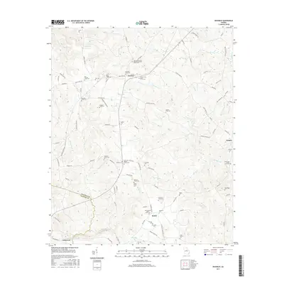
2017 Map of Devereux
USGS Topo · Published 2017About this map
The community of Devereux sits at the northern end of this survey, serving as a central point for a landscape defined by small settlements and numerous family burying grounds. The area is intersected by a complex drainage network including Fort Cr, Mill Cr, and Sheep Cr, which flow through the undulating terrain of Hancock County. To the south, Beulah appears as a secondary hub of local activity, marked by its namesake Beulah Cem and the nearby Second Beulah Baptist Church Cem. The distribution of family-named landmarks such as the Thornton Family Cem and Devereux Family Cem suggests a long-standing pattern of multi-generational land ownership. The presence of the Hancock Co Baldwin Co boundary line at the southwest corner illustrates the rural divide between these two Georgia districts during this era of modern mapping.
Find a feature on this map
102 named features on this map. Tap any name to fly to it.
Don’t see what you’re looking for? This feature index may not catch every label — zoom into the map to look around manually.
Map Details
Editions of this 2017 Devereux Map
This is the sole edition of this map. No revisions or reprints were ever made.
Other maps of this area

1912 · Milledgeville
USGS Topo · 1:62,500

1953 · Athens
USGS Topo · 1:250,000

1958 · Athens
USGS Topo · 1:250,000

1959 · Athens
USGS Topo · 1:250,000

1961 · Deepstep
USGS Topo · 1:24,000

1961 · Warthen NW
USGS Topo · 1:24,000

1963 · Athens
USGS Topo · 1:250,000

1972 · Shoulderbone
USGS Topo · 1:24,000
1972 · Devereux
USGS Topo · 1:24,000
1972 · Lake Sinclair East
USGS Topo · 1:24,000