
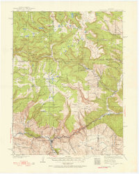
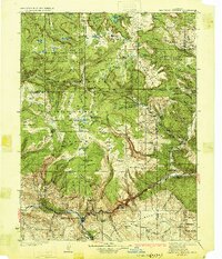
2000 Map of Devils Causeway
USGS Topo · Published 2004About this map
The Flat Tops plateau dominates this high-altitude landscape along the border of Rio Blanco and Garfield counties. This 2000 revision by the USDA Forest Service details a region defined by dramatic vertical relief, where the towering Chinese Wall and the narrow ridge of the Devils Causeway separate vast alpine basins. The area serves as a significant hydrological headwaters, feeding the North Fork White River to the southwest and the East Fork Williams Fork to the north.
Find a feature on this map
66 named features on this map. Tap any name to fly to it.
Don’t see what you’re looking for? This feature index may not catch every label — zoom into the map to look around manually.
Map Details
Editions of this 2000 Devils Causeway Map
This is the sole edition of this map. No revisions or reprints were ever made.
Other maps of this area
1927 · Glenwood Springs
USGS Topo · 1:125,000
1930 · Glenwood Springs
USGS Topo · 1:125,000

1954 · Craig
USGS Topo · 1:250,000

1957 · Craig
USGS Topo · 1:250,000

1957 · Leadville
USGS Topo · 1:250,000

1958 · Craig
USGS Topo · 1:250,000

1959 · Leadville
USGS Topo · 1:250,000

1960 · Leadville
USGS Topo · 1:250,000

1960 · Craig
USGS Topo · 1:250,000

1962 · Leadville
USGS Topo · 1:250,000