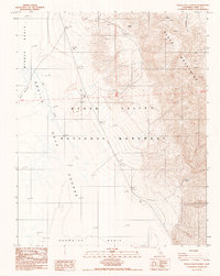
1988 Map of Devils Golf Course
USGS Topo · Published 1988About this map
Death Valley National Monument reveals a landscape defined by extreme elevations and mineral deposits as they were recorded in the 1980s. The map focuses on the crystalline salt structures of the Devils Golf Course and the vast Badwater Basin, where numerous benchmarks indicate depths well below sea level, such as TLC BM -237.0. To the east, the steep rise of the Black Mountains features unique geologic landmarks like the colorful Artists Palette and the carved Corkscrew Canyon. Evidence of the region's industrial past is visible near the northern edge of the range, where a Borax deposit is noted. The drainage of Salt Creek feeds into expansive Salt Flat areas, while the Devils Speedway provides a rare point of access through the basin's floor. This survey documents the precise topography of one of the lowest points in North America before subsequent boundary changes and park status reclassifications.
Find a feature on this map
24 named features on this map. Tap any name to fly to it.
Don’t see what you’re looking for? This feature index may not catch every label — zoom into the map to look around manually.
Map Details
Editions of this 1988 Devils Golf Course Map
This is the sole edition of this map. No revisions or reprints were ever made.
Other maps of this area

1908 · Furnace Creek
USGS Topo · 1:250,000

1910 · Furnace Creek
USGS Topo · 1:250,000

1948 · Death Valley
USGS Topo · 1:250,000

1951 · Funeral Peak
USGS Topo · 1:62,500

1952 · Furnace Creek
USGS Topo · 1:62,500

1952 · Ryan
USGS Topo · 1:62,500

1952 · Bennetts Well
USGS Topo · 1:62,500

1954 · Death Valley
USGS Topo · 1:250,000

1956 · Death Valley
USGS Topo · 1:250,000

1957 · Death Valley
USGS Topo · 1:250,000