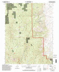
1994 Map of Devils Head
USGS Topo · Published 1998About this map
Devils Head and the surrounding Pike National Forest define this 1994 U.S. Forest Service and USGS revision of the Front Range. The map reveals a fascinating mix of institutional and spiritual land use, ranging from the youth-oriented Silver State Youth Camp and Camp Colorado to the distinct presence of the Shamballah-Ashrama and the Brotherhood of the White Temple near Gott Mountain.
Find a feature on this map
33 named features on this map. Tap any name to fly to it.
Don’t see what you’re looking for? This feature index may not catch every label — zoom into the map to look around manually.
Map Details
Editions of this 1994 Devils Head Map
This is the sole edition of this map. No revisions or reprints were ever made.
Other maps of this area

1893 · Platte Canyon
USGS Topo · 1:125,000

1894 · Castle Rock
USGS Topo · 1:125,000

1913 · Castle Rock
USGS Topo · 1:125,000

1940 · Castle Rock
USGS Topo · 1:62,500

1945 · Castle Rock
USGS Topo · 1:62,500

1945 · Platte Canyon
USGS Topo · 1:24,000

1945 · Kassler
USGS Topo · 1:24,000

1948 · Kassler
USGS Topo · 1:24,000

1948 · Platte Canyon
USGS Topo · 1:24,000

1953 · Denver
USGS Topo · 1:250,000