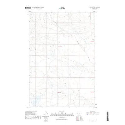
2020 Map of Devils Hole Lake
USGS Topo · Published 2020About this map
Devils Hole Lake anchors the southern portion of this high-plains landscape, where intermittent drainages define the movement of water across the open range. The topography is dominated by a series of creek beds, including the winding paths of Willow Cr and Minerva Cr, which intersect with the singular arterial route of Snowy Mountain Rd. These seasonal waterways, such as Spring Cr and Dry Cr, carve subtle elevation changes into the terrain, reflecting the typical drainage patterns of Musselshell County. The map provides a clear look at the Public Land Survey System divisions, with section lines and township boundaries like t11n r22e framing the sparsely settled ranching country of Central Montana. This modern survey is particularly useful for identifying the specific watersheds and access roads that have remained consistent across generations of land use.
Find a feature on this map
12 named features on this map. Tap any name to fly to it.
Don’t see what you’re looking for? This feature index may not catch every label — zoom into the map to look around manually.
Map Details
Editions of this 2020 Devils Hole Lake Map
This is the sole edition of this map. No revisions or reprints were ever made.
Other maps of this area

1889 · Big Snowy Mountain
USGS Topo · 1:250,000

1893 · Big Snowy Mountain
USGS Topo · 1:250,000

1954 · Roundup
USGS Topo · 1:250,000

1958 · Roundup
USGS Topo · 1:250,000

1970 · South Bench
USGS Topo · 1:24,000

1986 · Tyler
USGS Topo · 1:24,000

1986 · Devils Hole Lake
USGS Topo · 1:24,000

1986 · Pender Coulee
USGS Topo · 1:24,000

1986 · Emory School
USGS Topo · 1:24,000
1986 · Timber Buttes North
USGS Topo · 1:24,000