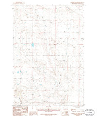
1986 Map of Timber Buttes North
USGS Topo · Published 1986About this map
Dry Pole Creek and its southern counterpart Pole Creek define the drainage patterns across this section of Musselshell County. The landscape is characterized by its intermittent water sources, where topographic depressions like Dry Lake and the Des Moines Lakes suggest a seasonal cycle of water retention. Toward the southwestern corner, the terrain rises significantly at the Timber Buttes, providing a stark contrast to the surrounding flats. Human activity is sparsely marked by a few utility features such as a Well and a Ditch, alongside scattered Springs, indicating the critical nature of water management in this arid environment during the mid-1980s. This survey, compiled from 1970s aerial photography, captures a moment before modern development altered the ranching and natural landscape of central Montana.
Find a feature on this map
8 named features on this map. Tap any name to fly to it.
Don’t see what you’re looking for? This feature index may not catch every label — zoom into the map to look around manually.
Map Details
Editions of this 1986 Timber Buttes North Map
This is the sole edition of this map. No revisions or reprints were ever made.
Other maps of this area

1954 · Roundup
USGS Topo · 1:250,000

1958 · Roundup
USGS Topo · 1:250,000

1979 · Roundup
USGS Topo · 1:100,000

1979 · Lavina NW
USGS Topo · 1:24,000

1979 · Timber Buttes South
USGS Topo · 1:24,000

1979 · Horsethief Creek
USGS Topo · 1:24,000

1986 · Devils Hole Lake
USGS Topo · 1:24,000

1986 · Pender Coulee
USGS Topo · 1:24,000

1986 · Lake Mason NW
USGS Topo · 1:24,000

1986 · Emory School
USGS Topo · 1:24,000