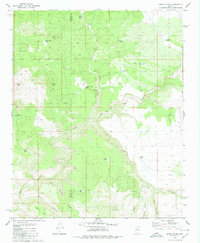
1980 Map of Devils Hump
USGS Topo · Published 1980About this map
Devils Hump and Indian Head dominate the topography of this high Arizona desert landscape, where water management is the primary sign of human activity. The map reveals an intricate network of stock-raising infrastructure, evidenced by family-named water sources like Jean Entz Tank, Butch Nichols Tank, and the Fred Cook Tank. These man-made tanks and natural springs, such as Willow Spring, are connected by a sparse network of Jeep Trails that traverse the complex drainages of Trout Creek and Cow Creek. The boundary between Mohave and Yavapai Counties runs through the center of the sheet, cutting across the expansive Cedar Basin. This 1970s-era survey captures the area before modern developments, showing a remote ranching environment defined by prominent landmarks like Thumb Rock and the sharp relief of Mohon Canyon and Panther Point.
Find a feature on this map
30 named features on this map. Tap any name to fly to it.
Don’t see what you’re looking for? This feature index may not catch every label — zoom into the map to look around manually.
Map Details
Editions of this 1980 Devils Hump Map
This is the sole edition of this map. No revisions or reprints were ever made.
Other maps of this area

1886 · Diamond Creek
USGS Topo · 1:250,000

1892 · Diamond Creek
USGS Topo · 1:250,000

1923 · Signal
USGS Topo · 1:250,000

1942 · Signal
USGS Topo · 1:250,000

1948 · Williams
USGS Topo · 1:250,000

1950 · Prescott
USGS Topo · 1:250,000

1954 · Prescott
USGS Topo · 1:250,000

1954 · Williams
USGS Topo · 1:250,000

1956 · Williams
USGS Topo · 1:250,000

1958 · Prescott
USGS Topo · 1:250,000