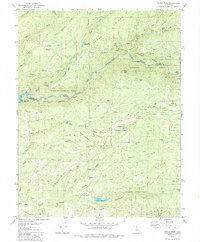
1979 Map of Devils Nose
USGS Topo · Published 1985About this map
The North Fork Mokelumne River carves a deep path through this Sierra Nevada landscape, serving as the boundary between Amador and Calaveras counties. By the late 1970s, the region was defined by a complex network of hydroelectric infrastructure, including the Tiger Creek Powerhouse, Tiger Creek Forbay, and the Tiger Creek Regulator Res. A system of conduits, siphons, and an aqueduct moves water across high ridges like Doaks Ridge and Cooks Station Ridge. Away from the river, the terrain rises into the Eldorado and Stanislaus national forests, where old logging or service routes like Winton Road and various jeep trails navigate the slopes of Bald Mountain and Devils Nose. Notable clearings and flats such as Whitmore Meadow and Hunter Flat provide distinct landmarks within the dense forest cover.
Find a feature on this map
56 named features on this map. Tap any name to fly to it.
Don’t see what you’re looking for? This feature index may not catch every label — zoom into the map to look around manually.
Map Details
Editions of this 1979 Devils Nose Map
3 editions found
Other maps of this area

1889 · Jackson
USGS Topo · 1:125,000

1889 · Pyramid Peak
USGS Topo · 1:125,000

1891 · Big Trees
USGS Topo · 1:125,000

1891 · Placerville
USGS Topo · 1:125,000

1891 · Pyramid Peak
USGS Topo · 1:125,000

1892 · Jackson
USGS Topo · 1:125,000

1892 · Placerville
USGS Topo · 1:125,000

1893 · Placerville
USGS Topo · 1:125,000

1894 · Big Trees
USGS Topo · 1:125,000

1895 · Pyramid Peak
USGS Topo · 1:125,000