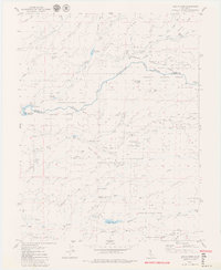
1979 Map of Devils Nose
USGS Topo · Published 1979About this map
The Mokelumne River and its various forks define this portion of the Sierra Nevada foothills during the late 1970s. The landscape is a complex network of hydroelectric infrastructure and resource management, evidenced by the presence of the Tiger Creek Reservoir, Tiger Creek Forbay, and Tiger Creek Regulator Res. A system of an Aqueduct, Siphon, and Flume connects these water bodies to a Powerhouse on the river banks, illustrating the mid-century engineering required to harness mountain runoff for power. Within the boundaries of the Eldorado National Forest and Stanislaus National Forest, the map reveals early logging and mining traces, such as a Prospect and several Quarry sites. Settlement is sparse, represented by named locations like Bruce Crossing and Hunter Flat, while remote access is maintained via the Blue Mountain Road and various unnamed Jeep Trails that traverse high points like Bald Mountain and Devils Nose.
Find a feature on this map
54 named features on this map. Tap any name to fly to it.
Don’t see what you’re looking for? This feature index may not catch every label — zoom into the map to look around manually.
Map Details
Editions of this 1979 Devils Nose Map
3 editions found
Other maps of this area

1889 · Jackson
USGS Topo · 1:125,000

1889 · Pyramid Peak
USGS Topo · 1:125,000

1891 · Big Trees
USGS Topo · 1:125,000

1891 · Placerville
USGS Topo · 1:125,000

1891 · Pyramid Peak
USGS Topo · 1:125,000

1892 · Jackson
USGS Topo · 1:125,000

1892 · Placerville
USGS Topo · 1:125,000

1893 · Placerville
USGS Topo · 1:125,000

1894 · Big Trees
USGS Topo · 1:125,000

1895 · Pyramid Peak
USGS Topo · 1:125,000