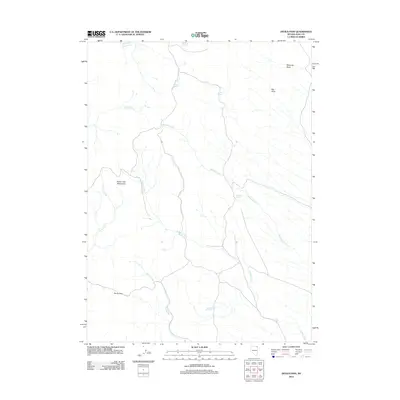
2012 Map of Devils Pass
USGS Topo · Published 2012About this map
Toana John Mountains dominate the western landscape of this Elko County quadrangle, where high-altitude desert hydrology dictates the locations of seasonal water sources. The terrain is defined by a network of drainages including Devils Creek, Badger Creek, and the extensive Boulder Creek system. These waterways are supported by scattered, named water points such as Moonshine Spring, Crocket Spring, and Winter Spring, which provided essential resources for land use in this arid environment. Significant geographic markers like Devils Pass serve as natural corridors through the varied topography. The map also identifies major land depressions like Mustang Draw and Big Draw in the northeastern section, reflecting the complex erosional patterns of the Great Basin during the early twenty-first century.
Find a feature on this map
15 named features on this map. Tap any name to fly to it.
Don’t see what you’re looking for? This feature index may not catch every label — zoom into the map to look around manually.
Map Details
Editions of this 2012 Devils Pass Map
This is the sole edition of this map. No revisions or reprints were ever made.
Other maps of this area

1955 · Wells
USGS Topo · 1:250,000

1957 · Delaplain
USGS Topo · 1:62,500

1958 · Wells
USGS Topo · 1:250,000

1961 · Wells
USGS Topo · 1:250,000

1961 · Delano Mountains
USGS Topo · 1:62,500

1961 · Gollaher Mountain
USGS Topo · 1:62,500

1968 · Texas Spring
USGS Topo · 1:24,000
1980 · Dry Canyon
USGS Topo · 1:24,000

1982 · Jackpot
USGS Topo · 1:100,000
1989 · Stratton Spring
USGS Topo · 1:24,000